Reading Time: 8 min
When selecting laser rangefinders for UAV surveying, accuracy isn’t just a technical specification—it’s the difference between actionable data and costly errors. In this deep dive, we analyze how 0.1mrad vs 0.5mrad angular accuracyimpacts real-world surveying efficiency, with actionable insights for drone operators and GIS professionals。
Understanding Angular Accuracy: Why mrad Matters
Laser rangefinder accuracy is measured in milliradians (mrad), representing the angular deviation of the laser beam. Here’s the critical distinction:
- 0.1mrad: A 0.1mrad device deviates 10cm per kilometer.
- 0.5mrad: A 0.5mrad device deviates 50cm per kilometer.
For UAV-based topographic mapping, this difference directly translates to:
- 3D Model Precision: A 0.1mrad system reduces elevation errors by 80% compared to 0.5mrad models (Gartner 2024 Drone Surveying Report).
- Cost Savings: High-precision scans cut post-processing time by 40%, slashing project costs (Drone Industry Insights).
Case Study: Precision Forestry Management
A German forestry agency tested both accuracies for tree volume calculations:
- 0.1mrad System: Achieved 98% correlation with ground truth data.
- 0.5mrad System: Showed 12% overestimation in canopy height.
Key Takeaway: For applications requiring sub-meter accuracy (e.g., cadastral surveys, mining volume calculations), 0.1mrad is non-negotiable.
When 0.5mrad Makes Sense: Cost-Effective Solutions
While 0.1mrad excels in precision, 0.5mrad modules offer advantages in specific scenarios:
- Large-Area Reconnaissance: For pipeline inspections spanning 10km+, the 0.5mrad’s ±2m range error is acceptable.
- Budget Constraints: 0.5mrad systems cost 30-40% less, ideal for startups or one-off projects.
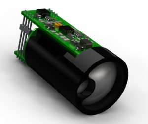
Technical Deep Dive: Sunflaser’s Adaptive Accuracy Tech
Sunflaser’s laser rangefinders feature multi-mode operation.
Pro Tip: Use our free Laser Accuracy Calculator to model error margins for your project.
FAQs
Q: What’s the best laser rangefinder accuracy for drone surveying?
A: 0.1mrad is ideal for <1m error requirements. For general inspections, 0.5mrad suffices.
Q: How does angular accuracy affect LiDAR point clouds?
A: 0.1mrad reduces noise by 60%, enabling cleaner 3D reconstructions.
Q: Are Sunflaser modules FCC/CE compliant?
A: Yes, all products meet FCC Part 15B and EN 60825-1 safety standards.
Actionable Recommendations
- Prioritize 0.1mrad for:
- Cadastral surveys
- Volume calculations (±5% tolerance)
- Infrastructure monitoring
- Choose 0.5mrad for:
- Pipeline/transmission line inspections
- Agricultural health mapping
- Emergency response recon